import numpy as np
from qtpy.QtCore import Qt
from qwt import QwtPlot, QwtPlotCurve, QwtPlotGrid, QwtPlotItem, QwtScaleDraw
from qwt.tests import utils
class CartesianAxis(QwtPlotItem):
"""Supports a coordinate system similar to
http://en.wikipedia.org/wiki/Image:Cartesian-coordinate-system.svg"""
def __init__(self, masterAxis, slaveAxis):
"""Valid input values for masterAxis and slaveAxis are QwtPlot.yLeft,
QwtPlot.yRight, QwtPlot.xBottom, and QwtPlot.xTop. When masterAxis is
an x-axis, slaveAxis must be an y-axis; and vice versa."""
QwtPlotItem.__init__(self)
self.__axis = masterAxis
if masterAxis in (QwtPlot.yLeft, QwtPlot.yRight):
self.setAxes(slaveAxis, masterAxis)
else:
self.setAxes(masterAxis, slaveAxis)
self.scaleDraw = QwtScaleDraw()
self.scaleDraw.setAlignment(
(
QwtScaleDraw.LeftScale,
QwtScaleDraw.RightScale,
QwtScaleDraw.BottomScale,
QwtScaleDraw.TopScale,
)[masterAxis]
)
def draw(self, painter, xMap, yMap, rect):
"""Draw an axis on the plot canvas"""
xtr = xMap.transform
ytr = yMap.transform
if self.__axis in (QwtPlot.yLeft, QwtPlot.yRight):
self.scaleDraw.move(round(xtr(0.0)), yMap.p2())
self.scaleDraw.setLength(yMap.p1() - yMap.p2())
elif self.__axis in (QwtPlot.xBottom, QwtPlot.xTop):
self.scaleDraw.move(xMap.p1(), round(ytr(0.0)))
self.scaleDraw.setLength(xMap.p2() - xMap.p1())
self.scaleDraw.setScaleDiv(self.plot().axisScaleDiv(self.__axis))
self.scaleDraw.draw(painter, self.plot().palette())
class CartesianPlot(QwtPlot):
"""Creates a coordinate system similar system
http://en.wikipedia.org/wiki/Image:Cartesian-coordinate-system.svg"""
def __init__(self, *args):
QwtPlot.__init__(self, *args)
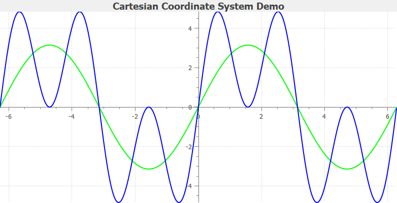
self.setTitle("Cartesian Coordinate System Demo")
# create a plot with a white canvas
self.setCanvasBackground(Qt.white)
# set plot layout
self.plotLayout().setCanvasMargin(0)
self.plotLayout().setAlignCanvasToScales(True)
# attach a grid
QwtPlotGrid.make(self, color=Qt.lightGray, width=0, style=Qt.DotLine, z=-1)
# attach a x-axis
xaxis = CartesianAxis(QwtPlot.xBottom, QwtPlot.yLeft)
xaxis.attach(self)
self.enableAxis(QwtPlot.xBottom, False)
# attach a y-axis
yaxis = CartesianAxis(QwtPlot.yLeft, QwtPlot.xBottom)
yaxis.attach(self)
self.enableAxis(QwtPlot.yLeft, False)
# calculate 3 NumPy arrays
x = np.arange(-2 * np.pi, 2 * np.pi, 0.01)
# attach a curve
QwtPlotCurve.make(
x,
np.pi * np.sin(x),
title="y = pi*sin(x)",
linecolor=Qt.green,
linewidth=2,
plot=self,
antialiased=True,
)
# attach another curve
QwtPlotCurve.make(
x,
4 * np.pi * np.cos(x) * np.cos(x) * np.sin(x),
title="y = 4*pi*sin(x)*cos(x)**2",
linecolor=Qt.blue,
linewidth=2,
plot=self,
antialiased=True,
)
self.replot()
def test_cartesian():
"""Cartesian plot test"""
utils.test_widget(CartesianPlot, (800, 480))
if __name__ == "__main__":
test_cartesian()